Find out what the Water Education Foundation is up to with
announcements about upcoming events, tours, new Western
Water articles on key water topics and more!
Sign up here to get announcements sent to
your inbox.
What is groundwater? Where does it occur in California? What is
an aquifer? What is overdraft? And how can groundwater be
managed? These are all important things to understand in a state
where 40 percent of the water supply comes from underground.
But what does an aquifer look like? And how is water extracted
for use on farms and in homes? Those questions are illustrated on
the Foundation’s beautiful California
Groundwater Map poster, which was updated and
re-designed earlier this year.
The Sierra Nevada mountains are dotted with orange and brown
patches of dead trees. The U.S. Forest Service estimates with
aerial surveys that more than 100 million trees have died in
California this decade, 62 million dying in 2016 alone.
What is groundwater? Where does it occur in California? What is
an aquifer? What is overdraft? And how can groundwater be
managed? These are all terms in the news as the state moves
forward with implementation of the landmark Sustainable
Groundwater Management Act (SGMA).
If you haven’t already heard, the Water Education Foundation is
turning 40 this year!
We are celebrating in style on Oct. 26 in Sacramento, with the
added bonus of a special reunion aimed at graduates of our Water
Leaders program, which is celebrating its own 20th birthday.
Registration is coming soon but you or your organization can
sponsor this special event now and secure seats at this limited
capacity event. The highest sponsorship level secures a full
table of 10 seats.
California’s 2017 fire season is underway, with several blazes
threatening land, property and lives across the state. The
impacts of a wildfire can linger long after the blaze has been
extinguished. Runoff from burned areas can carry ashes, dirt and
other debris into lakes and rivers, threatening wildlife and the
quality of drinking water. Our Headwaters Tour, September 13
and 14, will examine this and other water-related issues in our
forests.
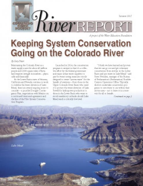
In the newly released Summer 2017 edition of River Report, Writer Gary Pitzer
delves into the successes and challenges of the Colorado River
Pilot Conservation Program.
The program was launched in 2014 as a collective effort by the
federal government and major urban water suppliers to pay for
water-saving measures strictly designed to create “system water”
for the benefit of everyone.
You can keep up to date with events, tours and other comings and
goings of the Water Education Foundation through social media.
We use our Twitter account @WaterEdFdn to keep you
posted on our upcoming events and tours, and to list the top
water stories from our week-day news aggregate known
as Aquafornia. We also tweet and
retweet breaking water news throughout the day.
In 2017, it is likely that no other water story grabbed as many
headlines in California and across the country as the flood
incident at Oroville Dam, the centerpiece of the State Water Project and
its largest water storage facility.
On our upcoming Northern California
Tour, we will spend time at the Oroville Dam visitor’s
center and meet with California Department of Water Resources
staff. You’ll see drone footage from February’s flood
incident, learn the engineering background on what led to it, and
hear about plans to stabilize the spillway before the next winter
storms and to finalize repairs by 2018.
The Water Education Foundation is gearing up to mark its 40th
anniversary on Oct. 26, 2017 as a widely respected nonprofit that
provides factual information on water issues in California and
across the West.
Starting today, follow us on Twitter or Facebook
as we countdown to our celebration with historical snippets and
photos each Thursday (#tbt, aka throwback Thursday)
using the hashtag #40YearsStrong
The Water Education Foundation is the California coordinator of
Project WET (Water Education for Teachers), an international,
award-winning nonprofit water education program and publisher.
California Project WET works with
water agencies, water research scientists, professors of teacher
education and after-school program directors to provide
high-quality professional development trainings for K-12
educators working in and out of the classroom.
Restoration practitioners, Delta landowners, regulators and
others are invited to attend a free July 25 workshop to help test-run and
develop a user’s guide to Delta restoration based on the
Delta Landscapes Project.
The Delta Landscapes Project (funded by the California Department
of Fish & Wildlife) seeks ways to achieve better restoration
results by understanding how the natural systems in the Delta
originally functioned during the early 1800s, before the
California Gold Rush and subsequent landscape-level changes.
Sixty percent of California’s developed water supply originates
high in the Sierra Nevada. Thus, the state’s water supply is
largely dependent on the health of Sierra forests, which are
suffering from ecosystem degradation, drought, wildfires and
widespread tree mortality.
Join us as we head into the Sierra foothills and the mountains to
examine water issues that happen upstream but have dramatic
impacts downstream and throughout California.
Learn about land subsidence problems caused by groundwater
pumping in the San Joaquin Valley and what is being done to
monitor the critical conditions at a free
briefing Aug. 16 at Fresno State.
Land subsidence caused by groundwater pumping has resulted in
subsidence rates in excess of 1 foot per year in some parts of
the region, putting state and federal aqueducts and flood control
structures at risk of damage.
The Summer 2017 California Project WET Gazette is “live” on the
Water Education Foundation website.
Water is flowing forth from the Sierra Nevada, as a record
setting snowpack begins to melt into a record setting flow of
liquid propelled downhill by gravity. How to better capture,
store and release more of this water from abundant storm years
has been a big topic of discussion among California water
managers and water user groups over our past decade of multi-year
droughts, punctuated by a great deluge of precipitation in a
single water year.
Our annual Bay-Delta
Tour, June 14-16, has only a handful of seats remaining.
This comprehensive look at the hub of California’s water systems
is an amazing opportunity to get a behind-the-scenes
understanding of efforts to maintain water supplies,
water quality, farming, levee integrity, habitat for endangered
species, and many other topics. You’re accompanied by experts
every step of the way and granted access to facilities that are
generally closed to the public.
Speakers from the California Department of Water Resources,
NASA/JPL, and the U.S. Geological Survey will be on tap at a
free briefing Aug. 16 in Fresno, Land
Subsidence in the San Joaquin Valley.
Land subsidence caused by groundwater pumping has been a problem
for decades in the San Joaquin Valley, but an increased reliance
on aquifers during the last decade has resulted in subsidence
rates in excess of 1 foot per year in some parts of the region.
Aquafornia, the Water Education
Foundation’s aggregate of the top water news of the day, is
available as a free resource.
We post all water news pertaining to California and the
watersheds it depends on, including the Colorado River basin. We
also post the latest entries from our blog, Western Water on Tap.
One of the most frequently discussed animals in the
Sacramento-San Joaquin Delta is fish. From the anadromous life
cycle of the salmon to the controversial and little-understood
Delta smelt to invasive species such as the largemouth bass, few
animals have a larger impact on water policy and infrastructure
in the Delta than the dozens of native and introduced fish found
there, especially those species considered endangered.
Land subsidence caused by groundwater pumping has been a problem
for decades in the San Joaquin Valley, but an increased reliance
on aquifers during the last decade has resulted in subsidence
rates in excess of one foot per year in some parts of the region.
This subsidence has destroyed thousands of public and private
groundwater well casings in the San Joaquin Valley and now this
subsidence is putting state and federal aqueducts and flood
control structures at risk of damage.
The Water Education Foundation is well known
for its colorful, poster-sized maps that tell the story of our
most valuable resource.
The California Water
Map features natural and manmade water resources throughout
the state, including the wild and scenic rivers system, federally
funded projects, state-funded projects, locally funded projects
and saline or alkaline lakes. It was given a new look in 2016 and
remains our most popular item.